Aerial Drone Photography – Give Your Listings the Edge
There are angles that ground-level photography simply cannot capture — and for the right property, a single aerial shot can transform a listing from forgettable to unmissable.
Drone photography has moved from novelty to necessity in property marketing. For estate agents and letting agents in Oxfordshire — from Oxford city centre apartments to Cotswolds farmhouses — the ability to show a property from the air is a tool that genuinely sets your listings apart. With the UK drone economy projected to reach £42 billion by 2030 according to PwC, this technology is only becoming more embedded in the market, making now the right time to get ahead of it.
WHAT AERIAL PHOTOGRAPHY SHOWS THAT GROUND LEVEL CANNOT
Stand at the front of a property and you can capture the facade. Walk into the garden and you can photograph the outdoor space. But you can’t show the full extent of the plot, the relationship between the house and its surroundings, or the landscape context that makes an Oxfordshire rural property truly special — not without going up.
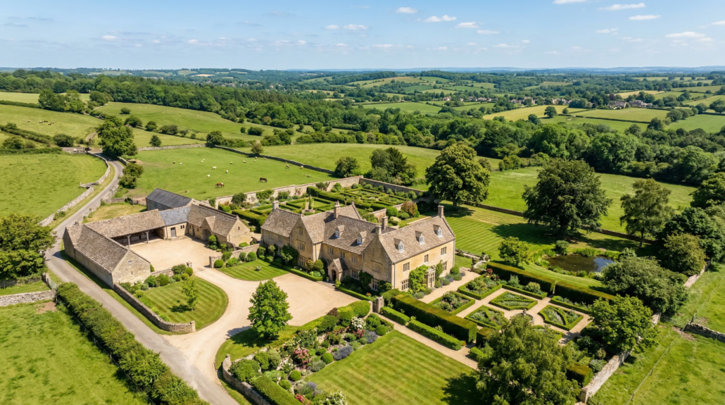
Aerial drone photography gives buyers a new way to understand a property before they visit. From above, you can clearly show:
- Plot size and boundaries: Buyers see exactly how much land comes with the property — information ground-level images can never fully convey.
- Parking and access: Driveways, garages, outbuildings, and access routes are instantly legible from above.
- Neighbourhood context: Proximity to green space, distance from road noise, the character of the surrounding area — communicated immediately.
- Rural setting and views: For properties in the Oxfordshire Cotswolds, the Chilterns, or the Vale of White Horse, the surrounding landscape is often a major part of the appeal.
IDEAL PROPERTIES FOR AERIAL PHOTOGRAPHY IN OXFORDSHIRE
Rural and equestrian properties benefit most obviously. A paddock, stable yard, or agricultural outbuilding is difficult to contextualise from ground level. From above, the full scale of the holding becomes clear immediately. For agents marketing equestrian or rural properties around the Cherwell Valley, the Evenlode corridor, or near Faringdon and Wantage, aerial photography is close to essential.
Large village and town houses with significant gardens also benefit strongly. Many buyers are specifically searching for outdoor space, and a drone image showing a generous private garden — particularly one backing onto open countryside or a river — can be the most compelling image in a listing.
Cotswolds village properties carry almost built-in visual appeal from the air. Stone rooflines, walled gardens, village greens, and church spires create a distinctly English landscape that buyers relocating from cities respond to emotionally — and a well-composed aerial shot of a property in Burford or the Bartons can stop buyers mid-scroll in a way no standard photograph achieves.
MORE COST-EFFECTIVE THAN YOU MIGHT THINK
Aerial photography used to mean hiring a helicopter — prohibitively expensive for most properties. Drone technology has changed this entirely. A professional drone pilot produces high-resolution aerial stills and footage at a fraction of the traditional cost, making it accessible for a much wider range of properties. For agents, it’s also a striking addition to your instruction pitch — immediately differentiating your marketing from competitors who rely solely on ground-level photography.
SOCIAL MEDIA IMPACT AND COMPLIANCE
Aerial footage performs exceptionally well on social media. A sweeping drone shot of a period property in Oxfordshire countryside stops the scroll in a way that static interior photography rarely achieves. For agents building a presence on Instagram, Facebook, or LinkedIn, drone footage provides a stream of share-worthy content that communicates the quality of your portfolio.
Always use a CAA-certified operator. In the UK, commercial drone operators must hold a Civil Aviation Authority Flyer ID and, where relevant, an Operator ID. Operations near Oxford Airport or above defined altitude thresholds require additional permissions. A certified operator ensures your photography is fully compliant, properly insured, and conducted safely.
FREQUENTLY ASKED QUESTIONS
Does drone photography work for urban properties, or only rural ones?
Drone photography adds value in urban settings too. For Oxford city properties, aerial shots can showcase proximity to university buildings, rivers, or parks. For larger townhouses or properties with notable gardens in Headington, Jericho, or Summertown, aerial imagery contextualises the property within its neighbourhood. That said, rural and semi-rural properties generally see the greatest uplift.
Are there drone flight restrictions in Oxfordshire?
Yes. The area around Oxford Airport (Kidlington) and certain other locations fall within controlled airspace where flights require advance authorisation. Restrictions also apply near prisons, hospitals, and crowded events. A professional, CAA-certified operator will be aware of all restrictions and obtain any necessary permissions before the shoot.
Can drone footage be combined with ground-level photography and video?
Absolutely — and this is best practice for most properties. A combined package of professional ground-level photography, interior video, and aerial drone footage gives you a complete marketing toolkit that addresses every aspect of the property. Mixing aerial establishing shots with internal video creates a compelling property narrative that performs exceptionally well across all channels.
How long does a drone photography session take?
For a typical residential property, a drone session can be completed in under an hour, often as part of a combined photography and video shoot. Weather is a factor — professional operators will advise on rescheduling if wind speeds make safe operation impossible. Edited aerial images are typically delivered within 24–48 hours.
E8 Property Services provides professional aerial drone photography for estate agents and letting agents across Oxfordshire. Whether you’re marketing a Cotswolds country house, a rural equestrian property, or a family home with exceptional outdoor space, our CAA-certified drone operators capture the perspectives that make your listings stand out. Book a session or call 01865 339535 to discuss your requirements.

